Project Details
Abstract
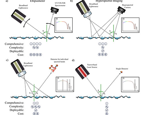 The project aims to quantify road surface condition under adverse weather in North Dakota. First, the current winter maintenance and winter road condition monitoring practices across North Dakota will be reviewed. Historical crash data will be used to identify high-risk roadway segments encountering elevated crash frequencies and/or severities related to adverse road surface conditions. The project aims to quantify the safety performance to estimate and predict crash occurrences related to adverse weather conditions using statistical modeling techniques and network screening analysis. Once the importance of road surface condition on safety is quantify, type of surface condition (ice, snow, slush) on highways using diffuse reflectance spectroscopy (DRS) will be identified. A physical model for near-infrared reflectance of road surface will be developed to classify the surface condition in a noncontact manner. The models will be developed under controlled conditions and will be evaluated under field condition by determination of the optical properties of water, snow, and ice (and black ice). In the next objective, DRS-based discriminative to measure brine eutectic point and efficacy will be developed by generating samples with different portions of water, salt, and beet juice (primarily used in North Dakota) under different temperature. Through noncontact quantification of deicer efficacy, the project contributes to preservation of transportation infrastructure and safety. The research team will develop deterministic and data-driven models to correlate DRS features under different brine conditions with respect to eutectic points in a controlled environment, and benchmarking and compare the results of DRS brine models with observations. The final task of this objective is to develop a low-cost in-situ optical sensor framework for field deployment using diode lasers, super luminescent LEDs, hyperspectral camera, single-pixel and array photodiodes, and spectral filters. The payload SWaP (size, weight and power) analysis for potential Unmanned Aerial Systems (UAS) applications. The research team will establish an UAS operation training program for students to get UAS licensed, to shadow UAS-assisted inspections, to analyze UAS data.
Project Word Files
project files
- UTC Project Information (Word, 96K)
Note to project PIs: The UTC document is limited to two pages. Also, it would be helpful if the Track Changes feature is used when editing either document above. Updated documents should be emailed to ndsu.ugpti@ndsu.edu.